|
|
Lake Shepherd Springs Climbing
Directions:
This is from the guidebook written by Karen Bockel and Roger Rains. You can buy the guidebook at The Pack Rat outdoor store in Fayetteville. To get to the crag from Fay., drive south on Hwy 71B. If you reset your odometer at the Fay. airport, at mile 20 you will see a dirt road (Winfrey Valley Road), going down to the left. This is one mile past the Mt. Gaylor Tower. Turn left down the road and after 1.25 miles turn right on Shepherd Springs Road. This junction is at Pense-Reed Cemetery. Follow this dirt road for 2.25 miles. You will see a pullout on the left side of the road with a small stone cairn (pillar of rocks). It is a little hard to find, the pullout is just before a little downhill. The pullout is only a wider area on the left side of the road, but is probably 75 yards long. Park here and walk 50yds up the road and take the trail to the right uphill through the woods. The trail will take you straight to the bluffline. The bluff is very visible during the colder months of the year.
|
|
|
Climbing at Shepherds:
Shepherd Springs currently has 37 developed routes ranging in difficulty from 5.7 to 5.12d and the tallest is about 60ft. The bluff is southeast facing and gets good morning sun and stays shaded in the afternoon. Most of the climbs are in the 5.11 range, all the sport routes have anchors and the cracks need gear for protection. There are two walkups, one on each of the bluff line. The crag is on National Forest, and hunting is very prominent in late November and early December. Be careful!
|
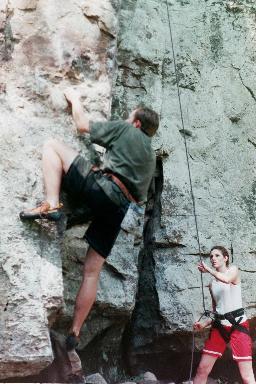
Rich on the Classic, Shepherd's Arete 5.10c
This is a great sport route, it will be the first climb you see from the trail when approaching the crag.
|
|
|